
Red Hook, Gowanus at risk for severe flooding
FEMA map red hook gowanus.jpg
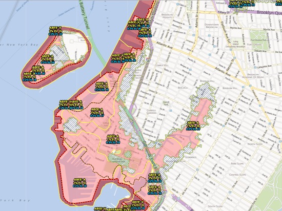
The Eagle has published the Federal Emergency Management Agency’s (FEMA’s) map showing vulnerable areas on Brooklyn’s southern shore in the wake of Hurricane Sandy. Just recently, FEMA published another section of its map, this one showing Red Hook and Gowanus (seen here). Unlike the NYC Office of Emergency Management’s (OEM’s) flood maps, FEMA’s maps are less used for disaster planning, and more used by insurance companies to set flood insurance rates – which are expected to go up in flood-prone areas. Red is obviously “Zone A.”
Leave a Comment
Related Articles

Brooklyn Bar Association teaches persuasive public speaking
The Zone gets bigger: New FEMA flood map impacts thousands of Brooklynites
Leave a Comment