City to mail preparedness guides to residents of evacuation zones
About a third of Brooklyn affected
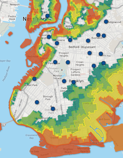
NYC Office of Emergency Management Commissioner Joseph F. Bruno has announced that 1.4 million New York City households and businesses in new Hurricane Evacuation Zones 1 through 6 will receive a copy of the new “Ready New York: Hurricanes and New York City” guide.
OEM’s new map doubles the areas that are prone to flooding. Zone 1 areas are the most vulnerable to storms, while Zone 6 areas are the least vulnerable.
Brooklyn areas that are now on the map include Bensonhurst, Coney Island, Gravesend, Sheepshead Bay and a wide swath of Southeast Brooklyn stretching north to Canarsie and East New York. On the west side of Brooklyn, vulnerable areas include the Sunset Park piers, Red Hook, Brooklyn Bridge Park, the Navy Yard area, and at least half of Greenpoint and Williamsburg.
Brooklyn Boro
View MoreNew York City’s most populous borough, Brooklyn, is home to nearly 2.6 million residents. If Brooklyn were an independent city it would be the fourth largest city in the United States. While Brooklyn has become the epitome of ‘cool and hip’ in recent years, for those that were born here, raised families here and improved communities over the years, Brooklyn has never been ‘uncool’.